
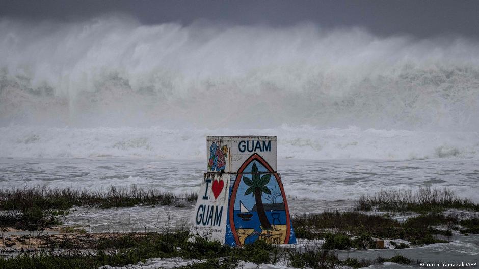
Super Typhoon Bavi Makes Landfall, Causes Major Damage
Super Typhoon Bavi, a formidable storm, made landfall near Guam, a United States territory situated in the western Pacific Ocean. The typhoon unleashed powerful winds and heavy rainfall across the Northern Mariana Islands, particularly impacting Rota, the southernmost island of the Marianas archipelago. Authorities have reported significant damage in the wake of the storm's passage.
The National Weather Service (NWS) confirmed that Bavi's western eyewall passed directly over Rota on Monday. At the time of landfall, the typhoon was characterized by an intensity of approximately 180 mph (290 kph) as it traversed Rota. The NWS issued stark warnings, emphasizing that "catastrophic winds exceeding 150 mph" would persist throughout Rota during the eyewall's transit. Forecasts from the Joint Typhoon Warning Center indicated that Bavi was moving westward across the archipelago on Monday morning, sustaining maximum winds of 280 kilometers (173 miles) per hour and gusts reaching 333 km/h.
Super typhoons are categorized by the NWS as equivalent to a Category 4 or Category 5 hurricane, denoting extreme destructive potential. The NWS had cautioned that this "very dangerous" typhoon was expected to inflict "catastrophic wind damage" in the vicinity of its eye, alongside the threat of storm surges and "hazardous" surf conditions.
Bavi's Predicted Trajectory and Devastating Impact
The eye of Super Typhoon Bavi was projected to pass closest to Rota, an island positioned between Guam and the Northern Marianas, around 8 am local time on Monday (2200 GMT Sunday). The NWS specifically warned of "extremely dangerous hurricane winds" for Rota, advising residents to treat the imminent extreme winds with the same urgency as an approaching tornado, urging immediate relocation to interior rooms or designated shelters.
The potential aftermath of Bavi's direct impact on or near Rota was described in grave terms by the NWS, suggesting that much of the affected area "will be uninhabitable for weeks, perhaps longer." The agency's projections included the destruction of numerous non-concrete, non-reinforced homes, anticipating total roof failure and wall collapse. Furthermore, it was predicted that "nearly all trees will be snapped or uprooted and power poles downed," leading to power outages that could last for weeks to several months. Flash flood warnings were also in effect for Saipan and Tinian, other islands within the Northern Marianas.
Community Response and Ongoing Recovery Efforts
The combined population of Guam and the Northern Mariana Islands totals approximately 210,000 residents. In preparation for the typhoon's arrival, the streets of these islands were largely deserted on Sunday afternoon as inhabitants heeded official guidance to seek shelter. Businesses, including shops and restaurants, had been boarded up in anticipation of Bavi making landfall either Sunday night or early Monday. Despite the widespread preparations, a small group of surfers was observed taking advantage of the turbulent conditions at Guam's Talofofo Bay.
Lou Rosario, the public information officer for Rota Municipal Operations Center, provided an update, stating, "We are hanging in there. We are experiencing heavy winds and flooding here... Some people already reporting major damages."
Region Still Grappling with Previous Storms
The arrival of Super Typhoon Bavi compounds the challenges for the archipelago, which is still recovering from the impact of Super Typhoon Sinlaku in mid-April. Sinlaku, identified as the strongest tropical cyclone globally earlier this year, caused extensive power outages for tens of thousands and resulted in widespread destruction. Parts of the Northern Mariana Islands have yet to see full restoration of power, with some residents continuing to live in temporary shelters due to their homes being destroyed by the high winds. The region also experienced another significant storm, Typhoon Mawar, in 2023, which was described as the largest in decades for the area.
El Niño's Influence on Storm Intensity
The increased intensity of tropical storms like Bavi is linked to higher ocean temperatures. June 2026 recorded unprecedented ocean temperatures globally, prompting a warning from the European Union that further records could be established in the coming months. The El Niño phenomenon, which typically occurs every two to seven years, has already commenced in the Pacific, as reported by the UN's World Meteorology Service. El Niño contributes to warmer ocean surface temperatures in the central and eastern Pacific Ocean, subsequently influencing global wind and weather patterns, often leading to more intense and wetter tropical storms.
Source: Original Article